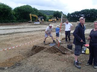
In the Summer of 2009 SSARG carried out a rescue dig of a Roman occupation/light industrial site at Castle Farm, South Cadbury.
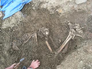
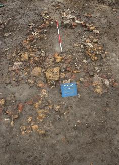
The site included pottery kilns, furnaces, ovens, plus burnt stone floor surfaces with later post holes suggesting post-Roman re-use of the site. There were also two large middens suggesting intensive occupation activity. The excavation also uncovered two human burials and a calf burial.
Working against the clock...
Excavation of a crouch burial.
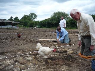
One of the farm yard's residents inspects the site!
Circular burnt stone feature. Possible corn dryer.
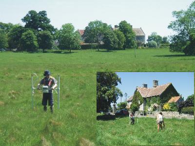
In 2009 SSARG carried out a gradiometer survey at Lytes
Cary Manor on behalf of the National Trust and the Charltons Historical
Society as part of the Lytes Cary Landscape Research Project. The
field to the west of the Manor House was scheduled in 1993 by English
Heritage as being the site of the Deserted Medieval Village Tuck's
Cary. The purpose of the gradiometer survey was to assess the condition
of the surviving earthworks and to add to what is known about the
extent and nature of the site.
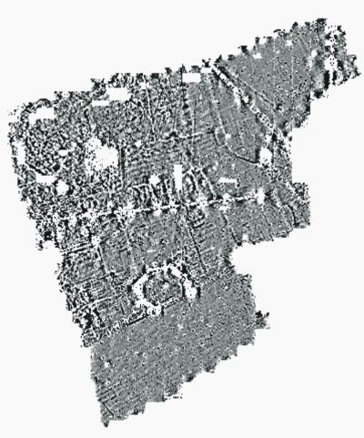
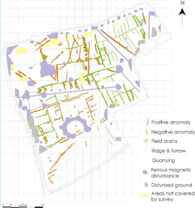
Survey results Interpretation
The survey has detected a series of linear anomalies on a southwest-northeast alignment which correspond with the existing earthworks and relate to the Deserted Medieval Village. There are, however, other linear anomalies on differing alignments which could relate to early phases of activity on this site. The results have been adversely affected by ferrous magnetic interference from modern pipelines, quarrying and a horseshoe shaped anomaly to the south which probably relates to a buried metal fence around a previous garden feature.
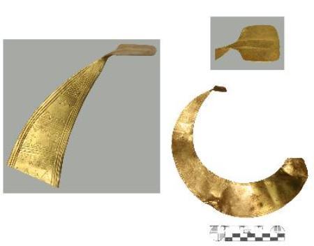
In the Summer of 2014 SSARG was approached by the Dorset County Council Portable Antiquities Officer about surveying the find site of the Tarrant Valley Early Bronze Age Lunula, the discovery of which had made the National Press earlier in the year. The survey was carried out in conjunction with members of the Stour Valley Search and Recovery Club who had discovered the lunula whilst metal detecting. Unfortunately the geophysical survey did not discover any features that appeared to be associated with the deposition of the lunula, but by using the grid set out for the geophysical survey, the metal detectorists were able to discover another section of the lunula.
Photo reproduced with the kind permission of Ciorstaidh Hayward Trevathen, Dorset County Council.
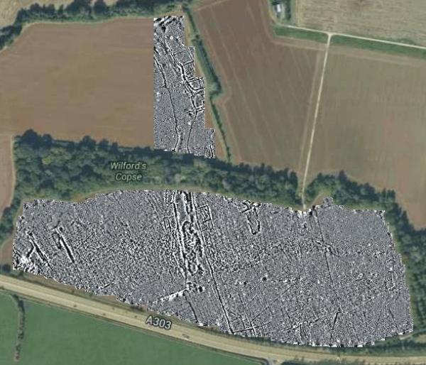
SSARG has carried out a major geophysical survey in Main Road Field, south of North Cadbury which is nearly 1km long. The results, confirmed by data from testpitting, reveal a substantial Iron Age trackway heading for South Cadbury Castle hillfort. Although this project is currently on hold we hope to continue with the geophysical survey over the next couple of years.
Map data copyright 2016 Google
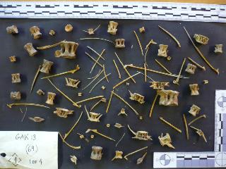
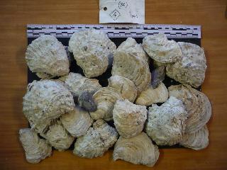
In 2014 SSARG members had the opportunity to
take part in post-excavation work on the fascinating environmental samples that
were taken from the Glastonbury Abbey Abbot’s Kitchen excavation in 2013.
Before sorting the samples were processed by GeoFlo - Southwest Geophysical and Flotation Services.
The washed residues from the samples contain a large
amount of oyster, whelk, mussel, and other shellfish, plus a huge
quantity and
variety of fish bones. This was a rare opportunity to gain an insight
into the everyday life of a nationally important scheduled monument.
After sorting the residues were sent to specialists for further analysis.
Between 1936 and 1968 60,000 examples of the K6
were installed. There are around 2,500 listings for the K6 kiosk in Great
Britain and Northern Ireland. There are approximately 8,400 non-listed K6
kiosks, giving a total number of surviving K6 kiosks of approximately 11,700
(about 20% of all K6 kiosks.
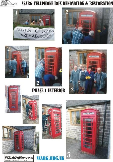
Phase 2 of our refurb and renovation of the call
box will turn the space into an archaeological information point highlighting
the rich diversity of archaeology in and around
Sutton Montis and its environs. It will be fitted out with a graphic
of the geophysical survey SSARG conducted prior to the test pitting
campaign of 2008/2009. There will also be a detailed graphic image of the ‘Pittmead’,
the field on opposite side of the road from the village Hall plus leaflets and
links for further information.
There appears to be a wide interest in the
telephone call box nationally, many having been converted into either book
lending/exchange points or defibrillator stations. Many more are there but
appear neglected or ‘abandoned’! A small amount remain active and ‘on line’
though these are generally found in towns, small market towns (Crewkerne,
Castle Cary etc).
The telephone call box, particularly the K6-a have
become part of the popular culture, they appear in artworks such as this installation
by Banksy (see ‘evolution of the call box’) and in tv programmes such as
Dr.Who.
I’ve included a couple of links for further
information should you wish to peruse this topic further. Go on I dare you! You
could give ‘em a call but…..